Auckland - The City of Sails

Auckland: The City of Sails

We start our first day of our road trip by heading to Auckland.  Typically, this is a 2.5 hour drive.  However, we anticipate it taking 3-3.5 hours due to the road closures, detours, and traffic delays caused by cyclone Gabrielle’s destruction.

Our first detour takes us along the coast at Waipu which is a small, windy road.  Large semi trucks, 18-wheelers, and other large vehicles are forbidden from traveling on this road.   But since the main Hwy is closed, they are all taking their chances.  It did not go well for this one truck that blocked our path for well over an hour.  The top photo is just one example of the damaged roads from the pounding rains and strong winds brought by Gabrielle.

Auckland

We meet up with Wayne at the Gamma Hotel and immediately head toward Viaduct Harbour for some lunch.  There are lots of cool restaurants, hotels, and shops by the wharf.  We settle on The Conservatory for lunch which is directly across from Team Emirates New Zealand’s America’s Cup home.  I met a few team members, but for the life of me I cannot figure out who the heck they are 🙂  So, if you recognize any of these fellows, please let me know their names.

Lucky for us, they brought out their two boats for a test run.  We watched them trailer the boats out of the hangar, install the mast, and use a massive crane to splash them into the water.

It seems like so much work to take these boats out for a two hour sail.  However, they work efficiently to get both boats out in less than 3 hours.

And off they go…with a tow by the chase boat (which has (4) 350hp engines)

We stop to have drinks at Brew on the Quay, then head back to the hotel.

Albert Park

There is a beautiful park within walking distance from the Gamma hotel called Albert Park.   We take a leisurely stroll throughout the park and enjoying its beauty.

There are stunning, old trees that wrap around the path and each other.

A little history of Albert’s Park

Albert Park in central Auckland was a military barracks during the conflict in Northland from 1845 to 1846. Troops were stationed there until 1871, when most of the buildings and walls were demolished. The park itself was constructed 10 years later.

There are lots of monuments dedicated to heroes and leaders.

The Sky Tower

The next day, we head to the Sky Tower, the tallest man-made structure in New Zealand. The Sky Tower is 328 meters tall, which is 8 meters taller than the Eiffel Tower and 24 meters taller than the Sydney Tower Eye. 

It took 2 years and 9 months to build this $85million (NZD) tower.  The Sky Tower weighs 21 million kilos or about 6,000 elephants.  It was constructed from 15,000 cubic meters of concrete, 2,000 tones of reinforced steel, and 260 panes of glass.

We truly enjoyed the beautiful views from the 51st and 60th floors.  They have a blue film or filter or light which made all of my photos blue.  They were cleaning the windows and I had a little fun with one of the guys hanging out on the outside of the tower.

Being the adventure capital of the world there are two crazy things you can do at the Sky Tower.  You can Sky Jump off the tower and fall 192 meters straight down or you can take a breath-taking walk perched high above the ground.  The boys had flip flops on so we could not do either of these nutso activities.  We did play around the glass floor panels….

The Maritime Museum of Auckland

You can’t go to the City of Sails without stopping by the Maritime Museum of Auckland.  This museum showcases the history of the city of sails, chronologically in New Zealand.  It was fascinating to learn about the different wakas and ships.

Huge Migration to New Zealand

They also had a separate wing dedicated to the millions of immigrants that came to New Zealand in the 1800-1900’s.  NZ attracted workers by offering them land (see add below).  Immigrants originally travelled in ships that took 6-8 months to cross the ocean. 

Inside, there was a room which they called the “sample” room.  It was meant to give you an idea of what it was like to live on the boat during the initial migration.  They had floors that tilted so you could experience what it was like to be at sea.  Families were squeezed into tiny bunks (top right and center right).  A century later, they figured out how to have drinking water and refrigeration along with actual cabins (bottom right).

They had lots of interactive areas that really gave you the feeling of what it was like back in the day.

  • Hotel: The Gamma Hotel
  • Kilometers Traveled: 185km
  • Travel time: 3.5 hours
  • Kilometers Walked: 10.4km on 21 Feb and 9.8km on 22 Feb

We really enjoyed our time in Auckland, but we need to move on to Waitomo.

Events from this blog occurred in mid-February.  Our blog posts run 10-12 weeks behind actual events.  This is the first blog post of our month-long road trip. Be sure to read our last blog where we highlight our overall road trip plan..

Road Trip Across New Zealand

The best way to see New Zealand is on land.  Sailing around New Zealand can be challenging as they have deep bays, rough seas, high winds, and not many anchor spots (so we have been told).  Plus, we have a lot of work going on Sugar Shack right now so moving her away from the docks is not really an option. So, a road trip is the perfect solution.

I had been planning this road trip for months and months.  Originally, Matt, Wayne, and I were going to take a campervan (or RV) but we decided to take our car instead.  Why do you ask?  Well, first of all the roads in NZ are incredibly windy, small, two lane (one lane each way) roads and driving a giant campervan seemed scary.  Also, the campervan sites are located between 2-10 miles away from the center of the main towns and we would not have had a way to get to and from the campsites.  And third, it was cheaper to take our car and stay in hotels than it was to rent the campervan.

We bought a car

You are probably thinking we are crazy, right? Well, we are a wee bit nutso, but not in this instance.  We were not planning on buying a car, but we did because the deal was just too good.  We bought a 2006 323i BMW with 18k miles for $3,800 USD.  Yep, and she was a beauty.

So, we had the reliable car, we had insurance, we had a jam packed itinerary full of action and adventure and we were set to go!

The Road Trip

Matt and I had already ventured to Coromandel and Whitanga which is on the East side of the North Island.  If you missed this blog, go back and read it! 

I had the opportunity to go to the North tip of the North island with friends and will take Matt back another time.  Check out this road trip to Cape Reigna.

So, our goal was to focus on the South Island. while still hitting a few highlights in the North Island.  We anticipated this being a 4500-5000km trip.  This is a rough idea of where we planned to go.  I anticipated several detours and unplanned stops along the way.

For the next three months, you will be reading all about our fabulous road trip, how long it took us to get to each destination, where we stayed, what we did, and what kind of mischief we got into with our friend Wayne.

So, please stay tuned and enjoy the ride!  It was a fantastic one.

Events from this blog post occurred between 20 February through 18 March 2023.  Our blog posts are running 10-12 weeks behind actual live events, so please be patient with us.

Great Barrier Island

We are free!!!  Oh my goodness after almost 3 months in the marina we finally break ourselves free to do some sailing around New Zealand.  We’ve been tied to the dock doing boat projects and meeting with different vendors and have not had a moment to go sailing until now.  We decide to head to Great Barrier island first and if time and weather permits, Mercury Island.

It is a slow motor down the Whangarei River.  We request permission to have the Te Matau a Pohe “Hook Bridge” open so we may pass under.  Still an amazing thing to see!

It is a beautiful day, albeit light wind on the nose.  We raise the main sail and continue on a motor sail as we don’t even have enough wind for the jib.  We pass by the Hen and Chickens Islands.  I just love their names.

Kaikoura Potato Bay

We approached Great Barrier Island and made the last minute decision to go to Smokehouse Bay which is supposed to be a nice boatie/cruiser bay.  However, when we approached we saw that there were close to 30 boats anchored there – so we stopped short and anchored in Kaikoura Bay also known as Potato Bay.  We had this beautiful bay all to ourselves.

We were expecting some ugly winds so we moved the following morning to a new bay.

Wairahi Bay

There were still a lot of boats at Smokehouse Bay so we decided to go to a bay just past it (still in Great Barrier Island).  We arrived to Wairahi Bay with 3 other boats.  Perfect!  From here we can easily visit the other bays within the western side of Great Barrier Island. We hang out in this anchorage for over  a week.  Several other boats joined us in this anchorage, but it is big enough to not feel crowded.

First, we explore the river that feeds into Wairahi Bay.  Matt took the SUP up the river during high and low tide so that he felt comfortable taking the dinghy with me.  It is so cool to be surrounded by hillsides, overhanging trees, and hidden houses. 

I spotted at least 5 hidden “baches” (summer houses) in the trees.

Smokehouse Bay

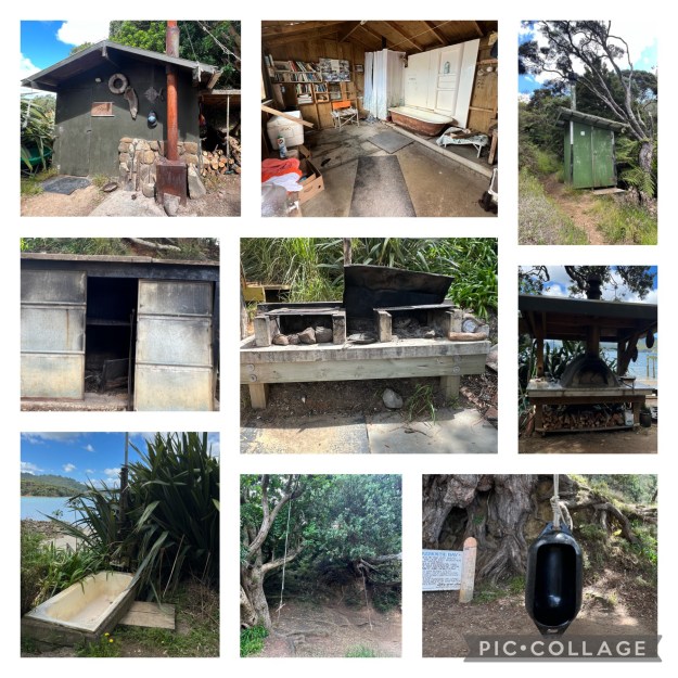
About 1 mile down from our anchorage is a popular spot called Smokehouse Bay.  It is a place created for locals and cruisers/boaties.  This as the anchorage that was incredibly busy when we first arrived. However, the weather changed which made this a very uncomfortable anchorage so everyone cleared out when we visited.  This is a shot during low tide (top) and high tide (bottom).

The facilities in this bay were provided by the late Eric Webster and his many friends.  Locals and cruisers maintain the property and equipment.  The Weber family placed Smokehouse Bay under the protection of the Queen National Trust as an open space covenant for the public whilst remaining in private ownership.

A massive rain storm destroyed Smokehouse Bay in November 2005.  Everything was covered in mud and debris and it took over a year to rebuild the facilities.

What can you enjoy at Smokehouse Bay?

  • Pizza Oven
  • Smokehouse (perfect for smoking fresh catch)
  • Grills
  • Laundry hand crank basins and clothes lines
  • (2) showers including 1 that offers hot water from a wood burning stove
  • Free book trade library
  • Toilets
  • Outdoor seating area around a bonfire
  • Great hikes on the 5 hectres (50 acres)

We enjoyed the entire bay to ourselves because it was inclement weather and all the boats left for a more protected anchorage.  We hiked to the summit and had excellent views of the bay.

Port Fitzroy

The most populated bay in Great Barrier Island is Port Fitzroy.  It is where you can get fuel and some supplies.  Super cute little town with a market, library, visitor center, and burger joint.  The town is the top photo.

There are two great hikes in this bay.  One starts from the center of town and leads you to a beautiful waterfall and the other is across the bay and leads you to a spectacular crows-nest view.

We decide to do the waterfall hike first, since we were already in town and it is only a 40minute hike to the falls.  But it is straight up.   First, you clean your shoes with a spray and scrub…then off you go down the path.

About 40-minutes, 300+ stairs, and 1.5 miles  later we arrive at the triple waterfall.

We take a moment to enjoy the beauty around us, dip our toes in (its freezing), and head back.

Next we take our dinghy across the bay and leave it at the dock (red arrow).  We then hike to the valley (green arrow on right), up to the peak and back down to the dock.  Super good hike.

At the top of the peak is a swing bridge that leads you to a 600-year old Kauri tree.  Once at the tree, you can climb up to the crows-nest to get a spectacular view of the bay.

As we make our way back down the hill we take a turn off to Sunset Rock.  I bet this would be wonderful to watch the sunset…

All in all we hiked 10.5 kilometers or 6.5 miles.  We were a bit bushed when we got back to the boat.

Historic Floods

We ended up spending a little more time in Great Barrier due to bad weather.  Lucky for us we were tucked away in the perfect anchorage for inclement weather.  Evidently this is a once in 50 year flood and yet it happened twice within a week!

Everything was flooded including the airport, grocery stores, and busses!

And of course the streets and highways.

We weather the second storm at a different bay called Karaka Bay at Great Barrier.   This was the calm before the storm.

Some more beautiful photos from Karaka Bay

I just love the stunning motus, rock formations, and islands.

Our friends captured us heading up the river, n our way back to the marina.

Events from this blog occurred in late January 2023.  Our blog posts run 6-8 weeks behind actual events.  Don’t miss our last blog where we explore the Lost Springs.